Stáhnout prezentaci
Prezentace se nahrává, počkejte prosím

1
November 18-21, 2013

2
Palacký University Olomouc est. 1573 23,000 students 2,500 employees Sts. Cyril and Methodius Faculty of Theology Faculty of Medicine and Dentistry Philosophical Faculty Faculty of Science Faculty of Education Faculty of Physical Culture Faculty of Law Faculty of Health Sciences

3
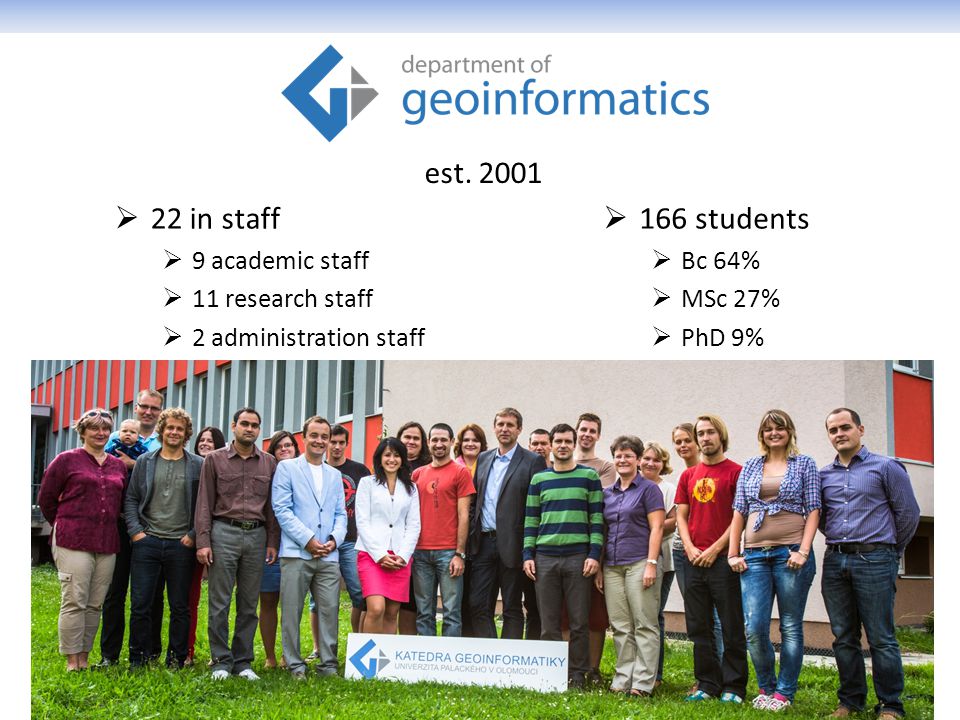
22 in staff 9 academic staff 11 research staff 2 administration staff 166 students Bc 64% MSc 27% PhD 9% est. 2001
4
Academic staff prof. dr. Vít Voženílek – thematic and atlas cartography assoc. prof. dr. Jiří Dvorský – software engineering assoc. prof. dr. Vilém Pechanec – GIS in environment dr. Jaroslav Burian – GIS in human geography dr. Jan Brus – GISc, spatial analysis dr. Zdena Dobešová – database systems dr. Jakub Miřijovský – Earth remote sensing, GNSS dr. Jana Svobodová – GIS in physical geography dr. Pavel Tuček – matematics, spatial statistics dr. Alena Vondráková – digital cartography

5
RESEARCH STREAMS

6
PhD study Geoinformatics & Cartography Vít Voženílek – Palacký University, Olomouc Jiří Dvorský – Palacký University, Olomouc Jan Andres – Palacký University, Olomouc Radomír Halaš – Palacký University, Olomouc Lenka Motyčková – Palacký University, Olomouc Jana Talašová – Palacký University, Olomouc Ján Tuček – Technical University in Zvolen (Slovakia) Milan Konečný – Masaryk University, Brno Jaroslav Hofierka – University of Prešov in Prešov (Slovakia) Bohuslav Veverka – Czech Technical University Václav Snášel – Technical University of Ostrava Jaromír Kolejka – Masaryk University, Brno Ján Feranec – Slovak Academy of Science, Bratislava (Slovakia) Jakub Langhammer – Charles University in Prague Jiří Horák – Technical University of Ostrava Jan Kolář – Charles University in Prague Jaromír Kaňok Lukáš Marek Vít Pászto Aleš Vávra Alžběta Brychtová Rostislav Nétek Stanislav Popelka Justyna Pastwa Jan Caha Vendula Hejlová Lenka Zajíčková Jitka Doležalová Zbyněk Janoška Pavel Samec Jana Měřičková
 Milan Konečný – Masaryk University, Brno Jaroslav Hofierka – University of Prešov in Prešov (Slovakia) Bohuslav Veverka – Czech Technical University Václav Snášel – Technical University of Ostrava Jaromír Kolejka – Masaryk University, Brno Ján Feranec – Slovak Academy of Science, Bratislava (Slovakia) Jakub Langhammer – Charles University in Prague Jiří Horák – Technical University of Ostrava Jan Kolář – Charles University in Prague Jaromír Kaňok Lukáš Marek Vít Pászto Aleš Vávra Alžběta Brychtová Rostislav Nétek Stanislav Popelka Justyna Pastwa Jan Caha Vendula Hejlová Lenka Zajíčková Jitka Doležalová Zbyněk Janoška Pavel Samec Jana Měřičková")
11
ČasBlokNázev příspěvku 16:00Registrace 16:30 - 18:00 Road Show Zkušenosti se zahraničními stážemi Studenti KGI 18:00 - 18:30 Cofee break 18:30 - 20:30 Road Show Zkušenosti se zahraničními stážemi Studenti KGI ČasBlokNázev příspěvku 8:00 - 8:30Registrace 8:30 - 10:00 Přednáško vý blok anglický Úvodní slovo StatGIS Team Vít Voženílek SmartGrid projects - Maps of Cooperation Mircea Ardelean City Center Delimitation - Olomouc case study Jaroslav Burian On Shape Metrics in Landscape Analyses Vít Pászto Analysing the spatio-temporal pattern of farmland change using landscape metrics Qiming Zhou 10:00 - 10:30 Cofee break 10:30 - 12:00 Přednáško vý blok anglický A Brief History of Big Data Mapping Francis Harvey Querying on Fuzzy Surfaces with Vague Queries Jan Caha The occurence classification of Norway spruce (Picea abies /L./ Karst.) decline Pavel Samec 12:00 - 13:00 Oběd 13:00 - 14:30 Přednáško vý blok anglický Current GIS challenge: getting better in technological skills, but still remaining geographer Vít Voženílek Geodata for administration and management of public transport in the Czech Republic Lenka Zajíčková Comparison of current SDI development topics in Central Europe with respect to spatial planning and Geoinformation policies Jiří Hiess Health Datasets in Spatial Analyses: What We Want, What We Get and What We Can Use Lukáš Marek Zóny ohrožení lesů v České republice Pavel Samec ČasBlokNázev příspěvku 9:00 - 10:30 Přednáškový blok anglický Towards a real-time landslide early warning strategy in Hong Kong Qiming Zhou Satellite generated brightness temperature (AMSR-E BT) influenced by landsurface Mukesh Boori Morphological analysis of the fluvial forms in the Morava River Jakub Miřijovský Combining Remote Sensing and Landscape Metrics for Urban Development to monitor Urban Spatial Variation Maik Netzband 10:30 - 11:00 Cofee break 11:00 - 12:15 Přednáškový blok anglický The Next Age of Discovery and a Future in the Post-GIS World Francis Harvey The spatial impact of high voltage transmission lines over the European landscape Mircea Ardelean Spatial and temporal analysis of extreme hydrological events in Lower Silesian Voivodeship (1994-2011) Justyna Pastwa Remote Sensing Data for the Mapping of Urban Poverty and Slum Area Maik Netzband 12:15 - 13:15 Oběd 13:15 - 15:00 Přednáškový blok český Restrikce měřící škály geodat pomocí genetických algoritmů Jiří Dvorský Srovnání klasických, fuzzy a posibilistických prahových hodnot v prostorových dotazech (Comparison of Crisp, Fuzzy and Possibilistic threshold in Spatial Queries) Jan Caha Chaotický fraktál nebo fraktální chaos...? Aplikace v geovědách Vít Pászto Fuzzy logika pro řízení světelné signalizace křižovatky Lenka Zajíčková Urbanisticko krajinárska štúdia Vinice – MČ Bratislava Rača Juraj Furdík 15:00 - 15:30 Cofee break 15:30 - 17:00 Přednáškový blok český Konceptualizace specializované edukace graduovaných uživatelů geoinformací v celoživotním vzdělávání se zřetelem na prostorové plánovače v ČR Jiří Hiess Hodnocení přesnosti výstupů z UAV fotogrammetrie Jakub Miřijovský Prostorová analýza výskytu kampylobakteriózy v České Republice Lukáš Marek Aktuální stav vývoje extenze Urban Planner Jaroslav Burian Sociální data jako zdroj pro studium percepce prostoru Vít Voženílek 17:00 - 18:00 Workshop Tvarové metriky a jejich použití v geoinformatice Vít Pászto, Lukáš Marek 18:00Social event ČasBlokNázev příspěvku 9:00 - 10:30 Workshop Jak rychle publikovat mapu na webu Martin Mikloš Vektorové formáty pro webovové mapy I Ondřej Růžička 10:30 - 11:00 Cofee break 11:00 - 12:30 Workshop Vektorové formáty pro webovové mapy II Ondřej Růžička ArcGIS - tipy&triky&vychytávky (co moc nefunguje ale jde to obejít) Jaroslav Burian 12:30 - 14:00 Ukončení konference, oběd Tuesday 19.11. (Hotel Flora) Monday 18.11. (KGI) Wednesday 20.11. (Hotel Flora) Thursday 21.11. (Hotel Flora)
 Jaroslav Burian 12: :00 Ukončení konference, oběd Tuesday (Hotel Flora) Monday (KGI) Wednesday (Hotel Flora) Thursday (Hotel Flora).")
12
Francis HARVEY University of Minnesota Dept. of Geography, Environment and Society Specialties Central and Eastern Europe Local governments Geographic Information Science (GIS) History of geographic thought Society and technology Publications Integrating Geodata Infrastructures from the Ground Up. Public Safety and GIS: What should certification accomplish? Developing geographic information infrastructures for local government: The role of trust. Boundary objects and the social construction of GIS technology. Research Activities Local Government Geographic Information Sharing: Examine issues impeding and improving information sharing among US local governments, ongoing Developing the Polish Cadastral Infrastructure: Study of cadastral related government activities in Poland with an emphasis on post-socialist transitional and EU accession issues, ongoing Collaborative Research: Graduate Ethics Education for Future Geospatial Technology Professionals: Research and teaching on issues related to GI professional ethics
 History of geographic thought Society and technology Publications Integrating Geodata Infrastructures from the Ground Up. Public Safety and GIS: What should certification accomplish. Developing geographic information infrastructures for local government: The role of trust. Boundary objects and the social construction of GIS technology. Research Activities Local Government Geographic Information Sharing: Examine issues impeding and improving information sharing among US local governments, ongoing Developing the Polish Cadastral Infrastructure: Study of cadastral related government activities in Poland with an emphasis on post-socialist transitional and EU accession issues, ongoing Collaborative Research: Graduate Ethics Education for Future Geospatial Technology Professionals: Research and teaching on issues related to GI professional ethics.")
13
Qiming ZHOU Hong Kong Baptist University Dept. of Geography Centre for Geo-computation Specialties Cartography Geographic Information Systems Remote Sensing and Image Interpretation Resource Management in China Publications Analysis of Spatio-temporal Pattern and Driving Force of Land Cover Change Using Multi-Temporal Remote Sensing Images Gradient Analysis of Landscape Spatial and Temporal Pattern Changes in Beijing Metropolitan Area Processing Multi-temporal Images for Detecting and Quantifying Spatial Pattern of Farmland Change in Western China Research Activities Change detection and land cover modelling with remote sensing DTM-based terrain analysis Spatial decision support systems 3-dimensional GIS GIS and remote sensing applications

14
Maik NETZBAND Ruhr-University Bochum Institute of Geography Palacky University Olomouc Dept. of Geoinformatics Specialties Social Sciences Earth Sciences & Environment Information & Communication Technologies Measurement of surface parameters in setteled areas, i.e. imperviousness, vegetation cover, surface temperature, bare soil, etc. Publications Synthesizing urban remote sensing through application, scale, data and case studies Urban Land Use Changes Monitoring Urban Change with ASTER data Flood risks in urbanized areas – multi-sensoral approaches using remotely sensed data for risk assessment Research Activities Urban remote sensing Spatial planning

15
Mircea ARDELEAN West University of Timișoara Dept. of Geography Specialties digital cartography GIS physical geography Publications Geomorphological Aspects of the Human Impact in the Alpine Area of Southern Carpathians The Use of the Digital Terrain Model in Analyzing the Natural Potential of the Muntele Mic Proposal regarding the building of electronic atlas of Banat Research Activities Complex method of digital geomorphological map building of Romania using GIS Digital geomorphological analysis and automated classification methods of landforms in mountain areas based on Digital Elevation Model and through remote sensing imagery integration Climatic change impact over the Holocene and present day dynamics of the alpine environments in Romanian Carpathians

16
Thank you for coming…. …. enjoy StatGIS!

Podobné prezentace


>")
 www.cuni.cz Jazykové kurzy – 1 rok – placené (po nich vstup.>")
 ->")
 - představení skupiny YIT 2. Ing. arch. Vladimír Dvořák (YIT Stavo) - aktivity a projekty YIT ČR.>")


 A ČESKÁ REPUBLIKA Z. Doležal, A. Kupčo.>")


, vybrán EK k financování Přípravné fáze v rámci RP7 Koordinátor:>")


